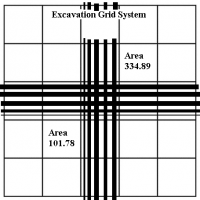
Example Archaeological Recording System
Archaeological recording is a systematic process. We capture a variety of different types of information and we must be able to perpetually recall and utilize these data. The recording system should be clear and understandable for the current excavation team, as well as for people who may want to reinterpret the data later - even decades later. The critical characteristic of our recording system is the ability to uniquely identify each thing we document. These things may include the areas we dig, the contexts we uncover, or the samples, such as pottery sherds or animal bones, that we collect. We also need to capture information about our process, such as who dug where on which days, and these people also need to be uniquely identifiable. We use an identifier to recall a particular record. If we want to query an area that was excavated, we need to be able to differentiate it from all other areas. If we want to pull out a particular pottery sherd, we need to be able to differentiate it from all other pottery sherds.
How do we develop a recording system that provides unique information for different things within an excavation? This usually begins with recording where we find contexts and samples. Each field project deploys different methods and terminology for locational data. In this guide, we will follow the excavation recording system outlined in Roosevelt, Cobb, et al (2015). This system uses UTM (Universal Transverse Mercator) coordinates to identify places of excavation. An archaeological site is mapped with a 10 meter by 10 meter UTM grid, with each grid square referred to as an area, and identified by the coordinate of the southwest corner. Assuming an archaeological site spans less than 10 kilometers, this system truncates the coordinate to only include the thousandth, hundredth, and tenth digits. In the following example, the area identified as 101.78 might actually be located at an easting of 521010m and a northing of 4410780m. (note: the dotted lines indicate that the image does not maintain a consistent internal scale, as the two areas are about 2 kilometers apart in the east-west direction, but only about 100 meters apart north-south)
Here, we zoom in to the top of each area, the ground surface before excavation. We record information about each area into the subsequent database table, indicating such characteristics as top elevations, date opened, and a description.
After recording area-specific data, we begin to dig within each area. As we remove soil, we start to observe changes. Maybe we uncover a pit or hearth containing bones, or we observe soil color differences across the area. Perhaps we find a volume of dirt filled with pottery sherds. Each of these observations indicates we are recognizing different contexts within the area. We must record each context separately before we continue to dig. Within each area, we name the contexts starting with number ‘1’ and increasing sequentially. Note that since all areas will have a context 1, this name alone is insufficient for uniquely identifying contexts across the site and in the database. The unique designation for each context must also include the area's identifier (such as 101.78.1). The following drawings show contexts within areas, followed by a database table recording information about those contexts.
The area (identified by area_easting and area_northing) and the context (identified by context_number plus the area) form the foundation of this recording system since together they indicate where things were found. For example, we can now collect a sample of pottery sherds from a context in an area. The sample receives a sequential identifier unique within the context, called a sample_number. Here again, sample '2' must also be identified with its area and context to be named uniquely across the entire site (such as 101.78.1.2). After all, many area/context combinations will contain at least two samples. Our interpretation of the data depends on maintaining the spatial information, the provenience, of each sample
Ultimately, archaeology is about good record keeping. We excavate in order to gather data that helps us interpret and understand the past. If we forget, or choose not, to identify things within the excavation, we lose those data forever. The only way to reproduce an excavation is through the detailed original records.
This page has paths:
- Relational Databases for Archaeology Peter Cobb